%20300ppi.png?height=120&name=Mapcreator%20logo%20(HubSpot)%20300ppi.png)
In this article, you will learn how to add the live layer with hotspot information from NASA Fire Information for Resource Management System (NASA Firms).
This documentation is always evolving.
Need a map with hotspot information in Europe or Australia? We have a live layer with hotspot information from NASA Fire Information for Resource Management System (NASA Firms), available in the Data Layers menu. The layer is continuously updated every hour. These hotspots are based on infrared radiation, so wildfires will be part of this data. However, not all NASA Firms hotspots are wildfires necessarily, as the infrared radiation detected can be the result of many other sources (volcanoes, industrial sites, oil refineries, campfires).
Next to the hotspots in Europe and Australia, we also offer Wildfire layers in the USA and Canada, which show wildfires and their perimeters.
This is how you can get it to work:
Select the EU and AU Fire hotspots – NASA Firms layer from the list of Data Layers. If you don’t find this layer in your menu, please contact our Support Team.
In the elements list, you now see the EU and AU hotspots group:
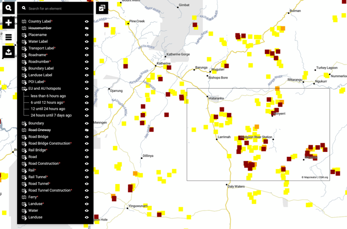
The following entries will be added in the EU and AU hotspots group:
.png?width=18&name=Icon%20legend%20-%20Nasa%20firms%20(Less%20than%206%20hours%20ago).png) Less than 6 hours ago
Less than 6 hours ago .png?width=18&name=Icon%20legend%20-%20Nasa%20firms%20(6%20until%2012%20hours%20ago).png) 6 until 12 hours ago
6 until 12 hours ago .png?width=18&name=Icon%20legend%20-%20Nasa%20firms%20(12%20until%2024%20hours%20ago).png) 12 until 24 hours ago
12 until 24 hours ago .png?width=18&name=Icon%20legend%20-%20Nasa%20firms%20(24%20hours%20until%207%20days%20ago).png) 24 hours until 7 days ago
24 hours until 7 days ago
You can make use of the hide function of the layer (eye symbol) to decide which hotspots you want to display.
How to get this map updated:
If you’d like to show this map on your website, we recommend you download this map as an iframe. The map published on your website will then also automatically update every 60 minutes.
And on a static map?
That’s very simple. Go to “Open Project” to look for this map you’ve already previously created. Reload your map and it will automatically also have the most recent data of the wildfires. Download your map again and you’re ready.